Twenty-five thousand years ago, the northern part of Wisconsin was buried under hundreds of feet of ice, and as the ice sheet advanced, receded and melted, it created a unique landscape to explore. In just over a week, we were able to visit three sites that highlighted the geologic forces at work.
After leaving the Isle Royale/Grand Portage area, we drove to the Apostle Islands area, to the picturesque town of Bayside. We signed up for a kayak tour along the lakeshore.

We met our guides early the next morning at Meyers Beach, where they gave a crash course in sea kayaking, including how to paddle, how to steer the kayak and most importantly how to work together to avoid conflicts between the front and back paddlers. They don’t call sea kayaks “divorce boats” for nothing.
We carried the heavy kayaks down to the beach in foursomes, and then split up two to a boat. Normally, Mrs. 123 sits in the back when we canoe or kayak, because she’s much more experienced at steering watercraft. I tend to steer like a drunken sailor.

For the next two hours, we explored the shore ducking into various sea caves and under archways carved out of the sandstone bluffs by wind and water.
I was sitting pretty snug in the back with just the minimum amount of leg room. The guides told us 6 feet is about the maximum height that can fit comfortably in the back of the kayak. I needed every inch of that space.
That made steering the kayak somewhat difficult. Sea kayaks have a rudder on the back, controlled by foot pedals that work in tandem. To turn left, you push your left foot forward and your right foot pulls back.

We started out ok, but somewhere in the middle of the paddle, my feet slipped off the pedals, and I struggled to get my feet back on them while seated in the kayak, with the spray skirt around my waist. My contortions to get back on the pedals must have dislodged something, because we suddenly lost the ability to turn left. One of the guides had to help us readjust the pedals so we could continue on our way.
The highlight of the tour was entering a sea cave that narrowed to a point where a kayak could go no further. We took turns going forward to that point, and then backing up until we could spin the kayak around and let another tandem in.

With more time and a higher budget, we would have hopped on a cruise to explore the islands that give the area its name. We opted instead for a lower-budget adventure, pulling out our bikes and riding up and down an unpaved trail along the shore.
Eventually we ended up in town and splurged on some ice cream by the harbor.

From Bayside, we headed southwest across Wisconsin to Interstate State Park, which sits on the state’s border with Minnesota. The states cooperate to run the park together, each managing the park on their side of the St. Croix River.
We stayed on the Minnesota side and toured an area known for its glacier potholes. When the ice sheet melted leaving this area under water, powerful eddies spun around and drilled holes into the rock. When the water receded, these holes were visible on the banks of the river. The holes filled with dirt and/or water, and only a few of these holes have been fully excavated.

The next day, I went for about a 5-mile loop hike from our campground into the town of Taylors Falls across to the visitors center and back to the campground. The hike starts with a steep staircase that climbs at least 100 steps up to the sandstone bluffs high above the river. Eventually that trail connected with a rails-to-trails conversion that heads right into town. (In case you’re wondering, the town is not named after Taylor Swift.)
In town, a ramp leads down to an underpass by the river, that crosses behind the main thoroughfare, and leads to the visitors center. There you can pick up a second trail that heads back to the campground.
After my hike, we drove over to the Wisconsin side of the park, which we found out charges a separate entrance fee from the Minnesota side. But the Wisconsin side is a federally-run park, so we were able to use our National Parks Pass to get in for free. Mrs. 123 got that parks pass as a reward in her library’s employee recognition program, and it has saved us hundreds of dollars over the course of the past year. The pass expires at the end of August, but we’ll gladly fork over $80 for a new one.

On the Wisconsin side, we visited the Ice Age Interpretative Center that has a somewhat cheesy movie with really bad acting that nonetheless does a nice job of explaining the geology of the region. The center is also the western terminus of the Ice Age Trail, which runs across the state along the line where the glacier stopped advancing. The trail runs for 1,200 miles, following in the footsteps of mammoths, and normally takes about two months for humans to compete.
From Interstate, we drove down to Prescott, and followed the Wisconsin section of the Great River Road to La Croix, and eventually over to the Wisconsin Dells. The Dells has been a tourist destination for 150 years. Originally, folks traveled to the Dells to take boat tours to see the rock bluffs and sandstone structures along the river. Over time, however, it’s become Las Vegas meets Orlando. The town is rife with amusement and water parks, and countless other attractions aimed at separating the tourists from their dollars.

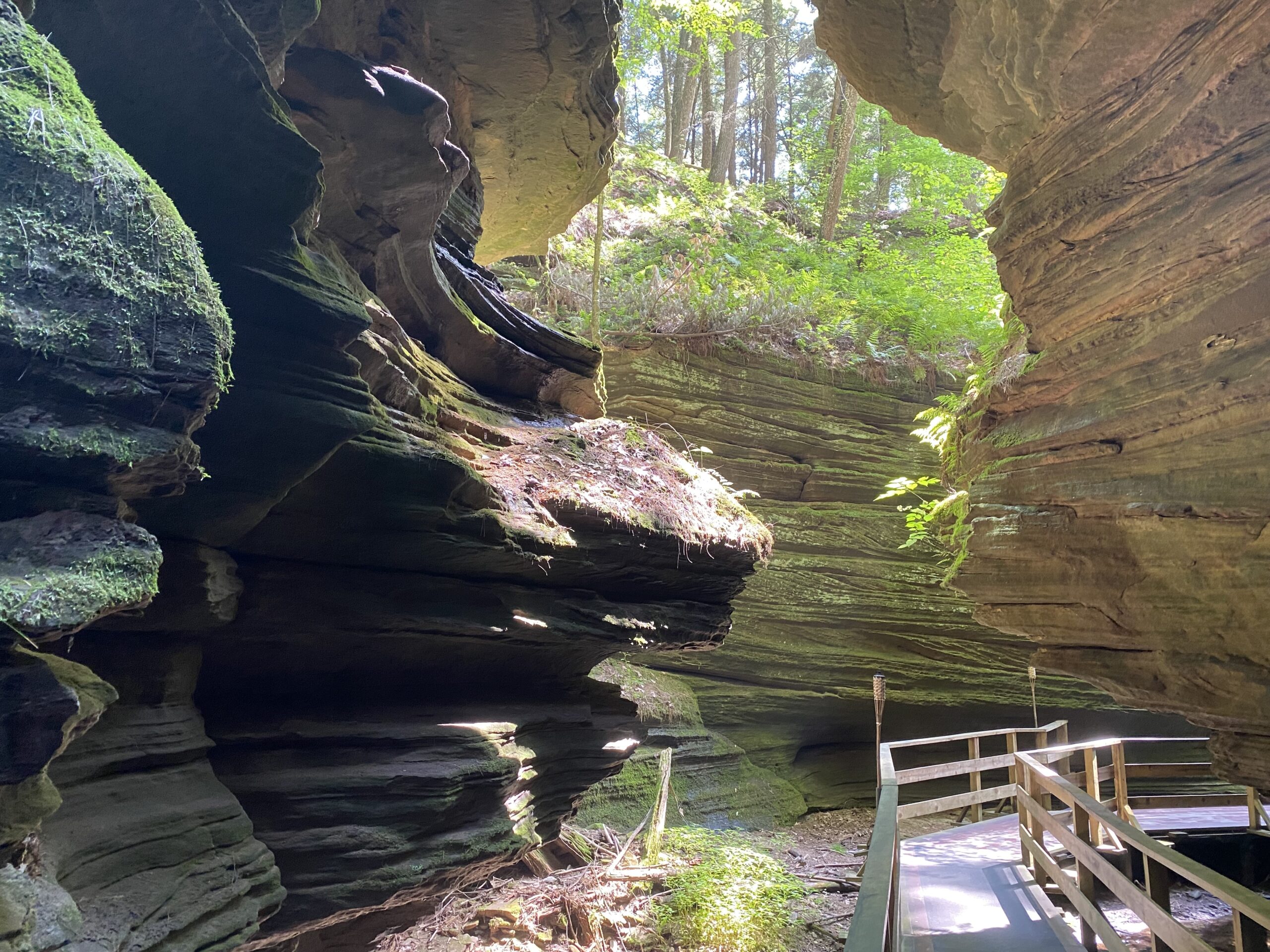
We limited ourselves to the boat tour. The classic Wisconsin Dells boat tour heads up river stopping twice so people can see some of the rock sculptures up close. Our first stop was Witches Gulch, a narrow cut through the rock walls that has now been outfitted with a boardwalk. At the end of the walk is a refreshment stand, which seemed to be doing good business with our tour group.
Back on the boat, we crossed to the other side of the river, and again disembarked to view the most iconic structure in the Dells, Stand Rock. the rock is a freestanding tower with a narrow base that widens to a flat top. It’s also the birthplace of stop-action photography.
For most of the 19th century, photography used cameras that could take minutes to complete a single exposure. Photo subjects had to stand motionless that entire time to get a clear image. Then in the late 1800s, a photographer who was trying to drum up interest in the Dells, invented a camera with fast shutter that could capture a sharp image of someone in motion.

To test out the camera, H.H. Bennett brought his 14-year old son to Stand Rock and told him to jump the three foot gap from the nearest cliff to the top of the rock 17 times until he captured the perfect image.
To recreate the magic, the tour arranged for a dog to make the jump instead. Humans are no longer allowed to make the leap themselves.
Following the tour, we took a short stroll on the Riverwalk, a quarter-mile trail that leads from the downtown area to a scenic viewpoint of the river.
The Dells seemed like it could be a fun town if you’re into amusement parks and theme restaurants, and you have deep pockets to pay for it all. We still think all the bright lights and adrenaline-pumping rides can’t hold a candle to mother nature.
Days: 201
Miles Travelled: 24,532
Next Stop: Pictured Rocks National Seashore

