After a month of sandy beaches and palm trees, it was time to leave the tropics and head north. We hadn’t realized it when we booked our stay in Gulf Shores, that we would be departing on Mardi Gras. And Gulf Shores is close enough to Louisiana to make that day a big deal.
We pulled out of the campground at about 10 a.m. just in time to drive through the town of Gulf Shores as people were gathering for the Mardi Gras parade. The road would close to traffic at 10:30, and we only had to get through about a mile of the parade route. But people were staking out their spots, wandering into the street oblivious to the 10,000 pound pickup truck and trailer combo bearing down upon them. But we snuck through in time without hitting any tourists, and drove the five hours north without any problems.

We had reservations at the Tannehill Ironworks State Park, about 30 minutes west of downtown Tuscaloosa. It’s a first-come, first served park, but the unseasonably cold temperatures meant there were plenty of spots available.
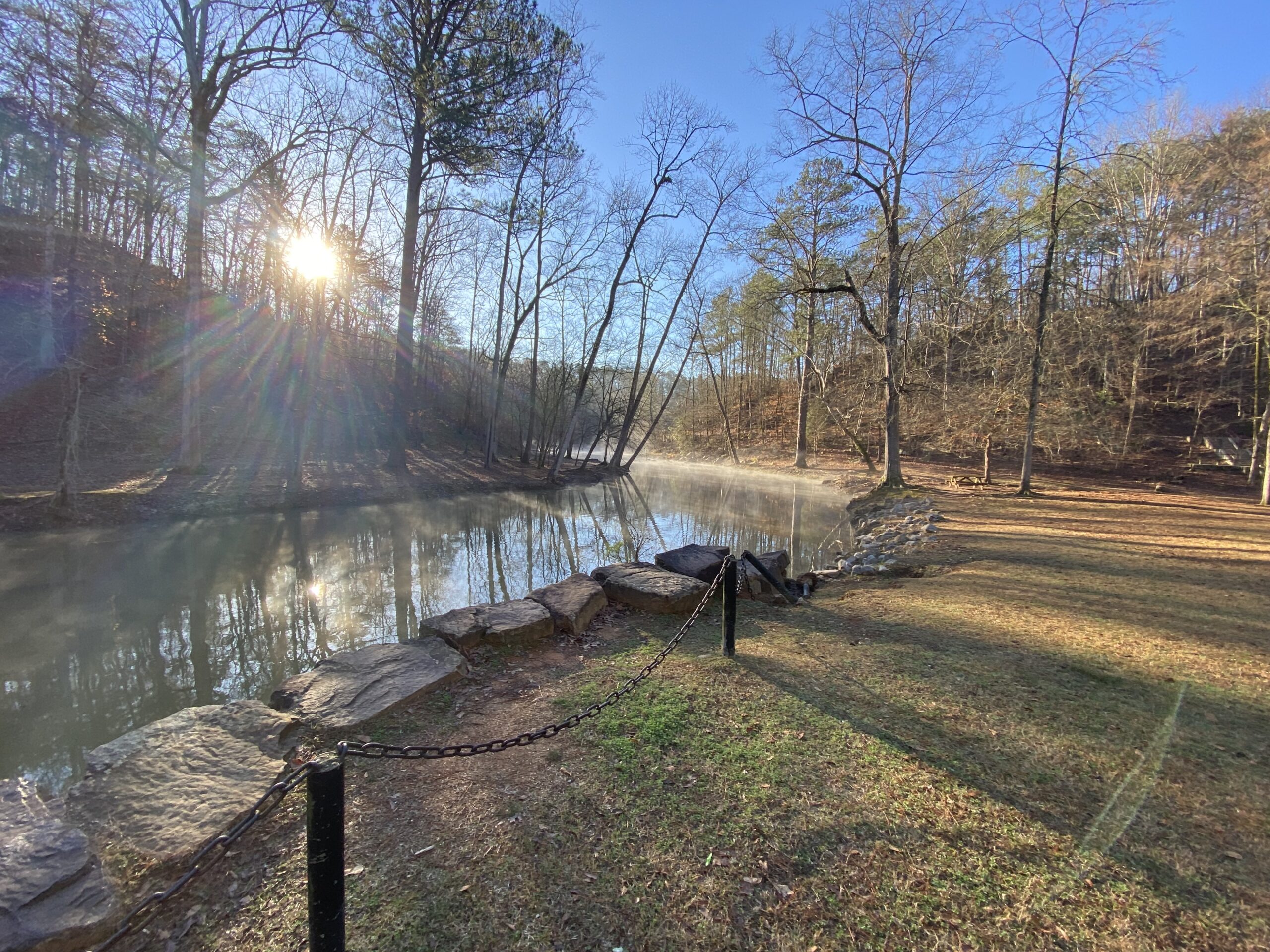
The park has a network of trails designed more for mountain biking, but fine for hiking as well. So the next morning, I rose early to get some trail miles in. The park was glorious and quiet, with steam rising from the river that flows through it.
The park is the site of an old iron foundry, used by the south during the civil war to make cannonballs. The impressive stone building still stands, along with a handful of wooden cabins.
The trail network is marked with posts color coded to correspond with the hiking trails on the park map. It was a little tricky figuring out which trail was which at first. Once I realized the marking system, it was a lot easier to navigate.

We drove into town and got some smoothies for lunch, before meeting friends whom we knew from Bend. Fran and John both taught at the University of Alabama and moved to Bend when they retired. But they were back in Tuscaloosa and kindly offered to show us around town.
Tuscaloosa, we would learn, went through a bit of a construction boom over the past decade thanks to the success of their football team under head coach Nick Saban. Many of the houses and apartments near the campus are now “game day houses” which rich alumni purchased to have a place to stay for the five or six home games in Tuscaloosa. They mostly sit empty the rest of the year. When Saban announced he was retiring earlier this year, property values dropped 20%.
The campus is beautiful with large grassy quads and red brick buildings with white columns. The university continues to grow and has made efforts to recruit top-notch out of state students by offering those with high GPAs and SAT scores a full four-year scholarship. Freshman are required to live on campus, unless they’re from Tuscaloosa, but after that first year, students must find off-campus housing or join a fraternity or sorority with annual dues of $10,000 or more.
We walked through the campus and down to the Riverwalk, a miles-long paved trail along the river that caters to runners, cyclists or anyone looking to stretch their legs. After our tour, Fran and John took us out for beers and then for a wonderful pizza dinner.

We returned to our campsite to find that one of our propane tanks was empty. With cold weather approaching, we decided to fill it that morning, rather than risking running out. We then drove out to Natural Bridge, a 148-foot sandstone bridge that towers 60 feet above winding pathways. It’s the longest natural bridge east of the Rockies. The bridge lies on private land but the owners have done a good job of building out trails in the area so you can see more of the local geology. One of the rock formation looks like an Indian head from a buffalo nickel. At first, we didn’t know what we were looking for and so we hiked beneath and around the formation in search of it. We finally had to go back to the gift store and ask for more specific instructions. The lady working behind the counter showed us a picture of it and told us to just look up from the trail. That did the trick.

The next day we drove down to Selma, to see the famous Edmund Pettus bridge that remains a landmark of the civil rights movement. On March 7, 1965, African American activists from Selma decided to march to Montgomery to demand the right to vote. They first had to cross the bridge on the way out of town. There they were met by police who dispersed the marchers in a brutal and bloody attack. The incident was a catalyst in getting the Voting Rights Act passed, and two weeks later, under federal protection, the marchers crossed the bridge and walked 54 miles over five days to get to Montgomery.
We walked across the bridge and back, feeling a flood of emotion. We were walking on sacred ground.
The interpretive center at the base of the bridge was being renovated, so we returned to our car and drove the route the marchers took toward Montgomery. Midway, we stoped at the Lowndes Interpretive Center which does a really nice job in explaining the march and what happened in Selma.

In Montgomery, we drove by the state capital and then stopped at the Civil Rights Memorial Center, adjacent to the Southern Poverty Law Center. The memorial was created by Maya Lin, the designer of the Vietnam War Memorial in Washington, D.C., and also features names engraved into black granite. Inside is a small museum which provides a good overview of the civil rights movement, as well as a short movie that brings the civil rights struggle forward to include the Black Lives Matter movement and the summer of reckoning after the murder of George Floyd. If I were to do it again, I would have come here last.
We then stopped at the Rosa Parks Museum, which is located right at the spot she was arrested for refusing to give up her seat on a segregated bus. The museum tour starts with a reenactment of the incident. Unfortunately, the second wing of the museum was closed, so we didn’t get to see a lot of the items on display, including her fingerprint card from when she was booked.

Our final stop was the National Museum of Peace and Justice, which we were told was the best museum in all of Alabama. We started at the outdoor exhibit, which memorializes the thousands of black victims of lynching. The memorial consists of large metal slabs either suspended from above or lying flat on the ground. Each slab represents one county, and is engraved with the names of known lynching victims. The numbers are just staggering and it represents only a small portion of actual lynchings. In most cases, nobody bothered to record the names.
From there we walked across the street to what we thought was the museum. As we walked up the stairs to the building, a bus driver called out to us to tell the building was closed. We were confused because they told us the last entrance to the museum would be at 4:15, and it wasn’t even 4 yet. What we didn’t realize was we were in the wrong place. The actual museum is a 10-minute walk away or a short ride by shuttle bus. So we missed one of the most important sites on our trip.
It had been a long and difficult day. Learning more about the civil rights movement and the incredibly inhumanity that man is able to muster against his fellow man is emotionally draining. It was hard not to draw parallels with a lot of the political rhetoric we hear today.

The following day we were supposed to move to another campground, at Cheaha State Park. But the weather had turned colder and since Cheaha is at higher elevation, temps there were even colder. The lows were supposed to drop to 23. While we knew we could stay warm in our trailer, I was worried about the water pipes on the exterior of the RV freezing. So we made the first alteration in our schedule. We canceled our reservation at Cheaha and booked another three days at Tannehill.
We spent the next day doing some hiking in the park, then went to tour Moundville, about 20 minutes southwest of Tuscaloosa. Moundville is the site of a prehistoric Native American city, including about a dozen large mounds built for ceremonial purposes or for the houses of the tribe’s leaders. You can climb a couple of the mounds and the informative signs help you visualize what the city looked like at its peak. The site was occupied from about 1000 to 1450, before ultimately being abandoned.
The grounds also hosts a museum, but most of the artifacts found during the excavation had been removed from their displays. Signs in the empty cases said the University of Alabama is negotiating with descendants of the tribe about what could be ethically displayed. The museum did a have a lot of mannequin displays that offered a glimpse of how these people lived and dressed.
It was the coldest day of our trip so far, and after walking around the mounds in the frigid winds, we met our friends again at a Ramen soup restaurant.

The next day, we drove out to Cheaha State Park on a day trip. Cheaha is the high point of the state, and you can drive right up to it. I decided I wanted to put a little more effort into reaching the high point of the state, so Mrs. 123 dropped me off at Cheaha Lake, and I hiked a mile, pretty much straight up, to the high point. The point is marked with a USGS benchmark in front of Bunker Tower, a stone Civilian Conservation Corps building with an observation deck on top.

We climbed up the tower which has a nice 360-degree view of the surroundings.
After a quick picnic lunch, we hiked a half mile out to Pulpit Rock, a rocky outcropping with a scenic view.
Our final day at Tannehill, we hiked some of the park’s trails and did a couple loads of laundry.
Driving through Alabama, we couldn’t help notice the tremendous poverty and the endless garbage strewn alongside the roads. It stood in sharp contrast with the wealth on display in Tuscaloosa.
Days: 44
Miles traveled: 6243
Next stop: Huntsville, Alabama


Walking on the bridge must be so awe inspiring…could imagine ghosts of the past changing history